
Table of contents
- The History of Estrada Nacional 2, the Portuguese Route 66:
- Route starting in Chaves, passing through Vila Pouca de Aguiar and Vidago:
- Tour from Peso da Régua and through the District of Viseu:
- In the District of Évora, municipality of Mora:
- In the District of Coimbra, the Sierra de Lousa:
- In the Faro District:
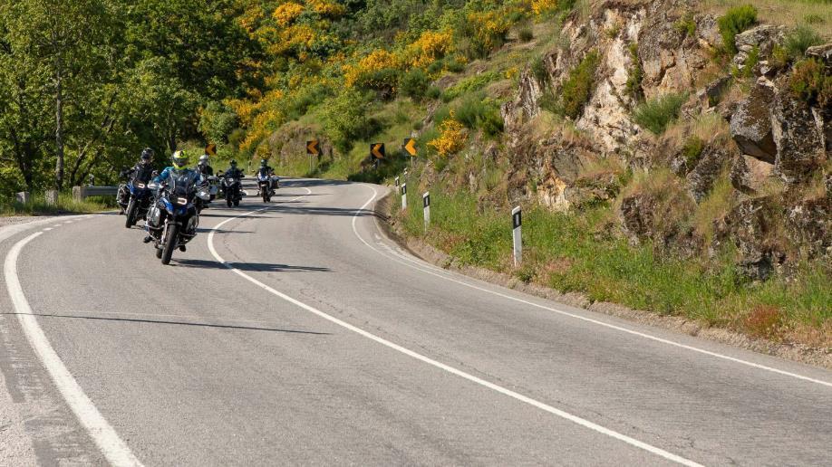
It is a route that runs through Portugal from north to south, that is, from end to end, crossing a little more than 739 km, starting in Chaves and ending in Faro; it somehow divides the country between west and east. It is a route that can be done both by motorcycle and by car, with the idea of promoting tourism in the interior of Portugal; knowing municipalities, towns, villages, rivers, among others.
An alternative for tourism that was inspired by the U.S. Route 66, but less long, and in this way to know and promote all the regions of the country. For this purpose, National Route 2 was chosen, a winding road with straight stretches, known as EN2. This, together with the American road and Route 40 in Argentina, are the three roads in the world that have the same style.
The History of Estrada Nacional 2, the Portuguese Route 66:
As already mentioned, this N2 road crosses Portugal from the north at the level of Chaves to the south, ending in Faro. Since 1945 it has been the national road of Portugal, being the longest in Europe. It arises from the union of others that already existed, from segments that were the Roman roads crossing Lusitania, and from others that were built in the following decades.
With the passage of time it became the main communication to the interior of the country by land. This route passes through 4 mountain ranges, such as Montemuro and Lousa, 11 rivers, including the Tagus and Douro, 11 districts, about 35 municipalities, 11 cities, spectacular scenery and much more.
Therefore, it is a perfect trip and an opportunity to know certain areas of Portugal, at inland level, that tourism gave little importance, such as the beautiful landscapes, villages, towns, gastronomy, friendliness of its people, among others; and is that usually the tourist programs are basically focused on Porto and Lisbon. Below, we will explain some of these places, following the order from north to south of the EN2 route and some interesting detours.
Route starting in Chaves, passing through Vila Pouca de Aguiar and Vidago:
- The city of Chaves, in the north of Portugal: it is located 10 km from the border with Spain and is the starting point of the EN2 route. This city is famous for the Trajan’s bridge, which in Roman times was used for communication between Braga and Astorga; and for the thermal waters, also from the same period. Located at the level of Tras-os-Montes, they are medicinal and hyperthermal waters.
They also contain many minerals and elements such as silica, sodium, fluorine, bicarbonate and hydrogen. Because of their high temperature, they stimulate physiological, metabolic, anti-inflammatory and pain-fighting functions and have an effect on joint functions.
- In the municipality of Villa Pouca de Aguiar: this Portuguese village with approximately 3500 inhabitants is located in the region of Tras-os-Montes and belongs to the district of Vila Real. Here we will find the Castle of Pena Aguiar if we turn off about 3 km from the N2 road.
The castle is located at the top of the Alváo mountain range, towards the east side. Although only its ruins remain, it can be climbed thanks to stairs and platforms that have been installed, so you can get a good view of the whole area.
- In the city of Vidago, the Salt Stones: this city is located only 1 hour away from the 2nd most populated city in Portugal, Porto. We are talking about the thermal village of the salt stones, a huge park that contains the spa, an old building of a casino from 1910, spaces for walks and original bungalows for accommodation. Interesting experience.

Tour from Peso da Régua and through the District of Viseu:
- Passing through Peso da Régua we find the famous Douro Vineyards: a little more than 100 km after starting the N2 route we get to the town of Peso da Régua, located in the western part of the north of the country, on the banks of the Douro River, which, although it is little traveled, there is a museum where they explain everything about wine and the river.
History tells that, during the 13th century, the city distributed Port wine. The surroundings of this city are full of beautiful vineyards, with nice viewpoints to take the best pictures. If you prefer, you can also visit these vineyards by boat on the Douro River.
- In the District of Viseu, the city of Lamego: from the Peso da Régua and crossing the Douro River is located the ancient city of Lamego, place where the first Courts, such as that of King Alfonso Henriques, were convened in the country. The city has several points of interest, such as the Sanctuary of Nossa Senhora dos Remedios, famous for the number of stairs it contains.
It can also be visited by car, either from below or from above. Another point is the Castle of Lamego, from the medieval period, surrounded by stone houses; and to reach it you go up the narrow Rua da Olaria. Of the castle only a tower and the wall remain.
- Also in the District of Viseu, the city of Santa Comba Dao: it is a small town, but has several places for recreation, such as its beaches, horseback riding, knowing certain monuments, viewpoints, as well as cathedrals and churches, the Roman bridge and, if it is Wednesday, take advantage of the fair of the week; that is, its market selling local products, such as fish, meat, fruits and sweets.
In the District of Évora, municipality of Mora:
- Brotas in the Alentejo region: this is a small village where you can see houses painted white with blue, different from the rest of the other villages in Alentejo, which are usually white with yellow. It is a quick walk because everything is summarized in a street of stones that leads you to the square, where the church of the fifteenth century called the Sanctuary of Our Lady of Brotas is located.
Its current style is a mixture of several styles, due to the different reconstructions that have been carried out during the course of time.
- Montemor-o-Novo, also in the Alentejo region: approximately 30 km west of Évora is the city of Montemor-o-Novo, which also functions as a municipality in the Alentejo region. Here you can visit the ancient castle, the Escoural Cave, with interesting rock art from the Paleolithic period, among other places.

- Aljustrel in the District of Beja, Alentejo region: village known and famous for its mines, its hermitage on the hill and the mills. It is located southwest of the city of Beja, about 34 km away. It was formerly called Vipasca and was a mining center exploited by the Romans, extracting gold, copper and silver.
Between the 19th and 20th centuries, bronze tablets dating from the time of Emperor Hadrian in the 2nd century were found, with annotations on the measurements and the law regulating the mining sector.
In the District of Coimbra, the Sierra de Lousa:
- Schist villages or towns: they are located between Coimbra and Porto, towards the eastern side of Portugal and near the border with Spain. Rural cottages, which have been built with schist or xisto, which is a material similar to slate stone and typical of the area.
There are 27 villages, and those closest to the route are Chiqueiro, Talasnal and Casal Novo. You can also enjoy the castle of Arouce from 1080, which has survived the wars of Christians and Muslims.
In the Faro District:
- In the Algarve region, São Brás de Alportel: this is a Portuguese village with about 10,000 inhabitants, and is one of the 5 municipalities that has a parish. Its streets are full of beautiful trees and flowers with roman sidewalks. In addition, you can visit the Verbena garden, its church and the Museu do Traje São Brás de Alportel.
- Algarve and its capital Faro: arriving at Faro is the culmination of the 739 km of the Estrada Nacional 2 route, the 66th route of Portugal. It is a somewhat large city, with an airport and was the ancient Roman city called Romano Ossonoba; with an interesting historic center and stone streets, as well as beaches, squares, the marshes of Ria Formosa or the area next to the marina.